This site uses cookies to improve your experience. To help us insure we adhere to various privacy regulations, please select your country/region of residence. If you do not select a country, we will assume you are from the United States. Select your Cookie Settings or view our Privacy Policy and Terms of Use.
Cookie Settings
Cookies and similar technologies are used on this website for proper function of the website, for tracking performance analytics and for marketing purposes. We and some of our third-party providers may use cookie data for various purposes. Please review the cookie settings below and choose your preference.
Used for the proper function of the website
Used for monitoring website traffic and interactions
Cookie Settings
Cookies and similar technologies are used on this website for proper function of the website, for tracking performance analytics and for marketing purposes. We and some of our third-party providers may use cookie data for various purposes. Please review the cookie settings below and choose your preference.
Strictly Necessary: Used for the proper function of the website
Performance/Analytics: Used for monitoring website traffic and interactions
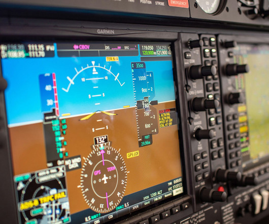
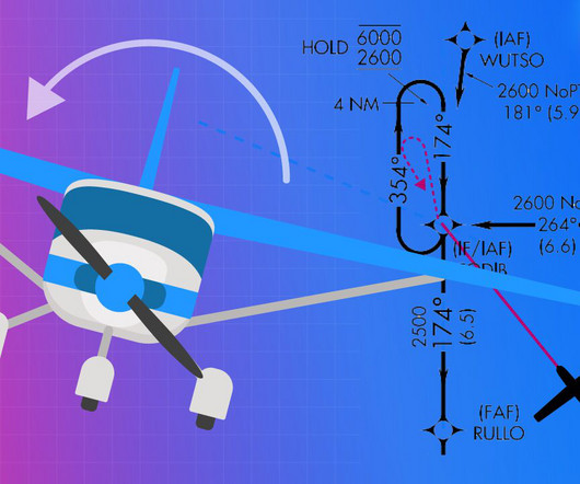
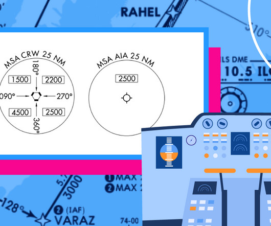
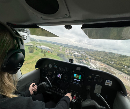
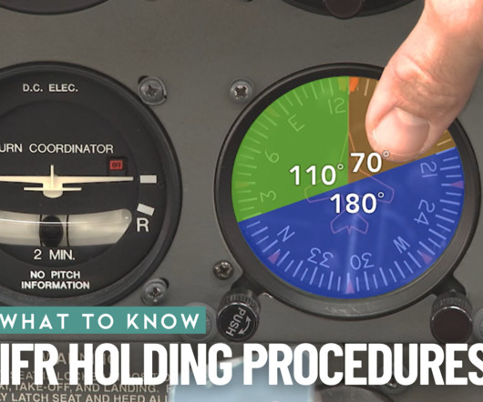
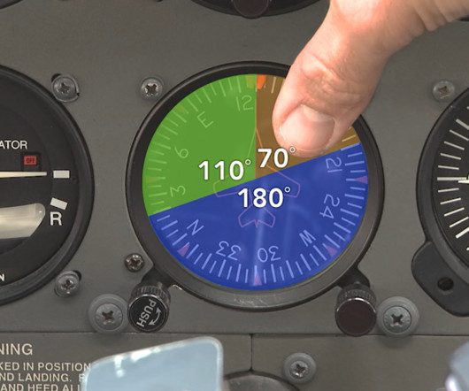
To my surprise, the Cessna 172S that I have flown for all my training for Private Pilot and Instrument training, had a lapsed 30-day VOR check. I went into the office and informed them of the out-of-date VOR check and a mechanic took the airplane up while I was doing the oral portion of the checkride to complete the VOR check.
Even driving a car can be dangerous in foggy weather. While it is particularly useful in low visibility or poor weather conditions, it is not limited to such situations. Air travel would be significantly reduced if aircraft were limited to landing only when the weather was perfect. Lets learn more about this system!
It was early winter, but the current skies and projected weather looked favorable, so I decided to fly rather than drive. I decided to fly first and eat later due to approaching weather (mistake #1), and, after a weather briefing, estimated I could get to Chicago (DuPage Airport (KDPA)) before the weather from the west did (mistake #2).
Are you curious about flying a VOR approach? If you’re aiming to master instrument-rated flying, it’d be valuable to learn about VOR approaches. We’ll cover what a VOR approach is, how to fly it step-by-step, and even whether GPS can replace it in today’s navigation. Ready to make VOR approaches easy?
Each class of airspace is depicted with unique markings on the sectional chart and different VFR weather minimums and equipment requirements. VOR/DME must complete an online course covering flight operations in the D.C. Take our latest quiz and test your knowledge of the U.S. airspace system. Both are correct.
This was in the early days of having weather radar displays available on portables, and I was glad I had it. The two storms were in tight formation, on the move, and bearing down on my next VOR waypoint, Youngstown, Ohio. I told him what I was seeing and asked for a dogleg to the south to another VOR.
Knowledge areas and tasks included in the ACS include weather theory, airspace, aeronautical charts, aircraft performance, and emergency procedures, to name just a few. Some pilots discover they need extra practice with performance landings or more time mastering VOR navigation, for instance. Remember that this is not a simple quiz.
Navigate also means managing weather, because thats often the biggest challenge on an IFR flight. We no longer need to worry about identifying VORs and dialing in the right radial, but we do need to worry about that thunderstorm sitting right on top of our direct route or the low ceiling at our destination. Is it all worth it?
The Demise of the Airway Beacon System: 1940s 1950s With the introduction of advanced radio navigation aids like VOR (VHF Omnidirectional Range) and ILS (Instrument Landing System) in the 1940s and 1950s, the Airway Beacon System began to lose its importance. Most issues regarding airport beacons are related to misidentification.
Youll learn how to navigate, communicate with Air Traffic Control, interpret weather, and conduct instrument approaches to airports, all without relying on whats outside your window. This rating adds an entirely new dimension to your skillsetand makes you a true all-weather aviator. What Is an Instrument Rating? Flight canceled.
For a flight under IFR or a flight not in the vicinity of an airport, weather reports and forecasts, fuel requirements, alternatives available if the planned flight cannot be completed , and any known traffic delays of which the pilot in command has been advised by ATC. Is there widespread fog?
Discussions may also cover weather interpretation, flight planning, and risk management. Weather Theory and Interpretation Weather is a critical factor in flight safety. Revisiting weather concepts, such as atmospheric pressure systems, fronts, and cloud formations, enhances your ability to make informed decisions.
Rather, it is affected by many factors, such as weather conditions and the presence of obstacles. Examples of information that can be communicated by an FSS include weather advisories, traffic advisories, navigational aids, or information from military bases or homeland security. VFR requires minimum weather and visibility conditions.
Subscribe Now Featured A) Two Radials Depicted From the STL VOR, there are two radials depicted that intersect with the final approach path—the R-144 and the R-194. Transitioning from the TOY VOR is also a heavy line radial along the R-261 and notes that no procedure turn would be needed (NoPT).
Pilots who miss this question will often select that the jet stream is stronger in the summer perhaps becuase the US typically sees more active weather patterns during this season, but it is, in fact, weaker due to the difference in temperature between the tropics and North America being less extreme in the summer. Refer to figure 34.)
Weather Report Interpretation Weather interpretation is an important skill all pilots must develop to make safe and smart decisions. Decoding and interpreting weather reports can be tough in the beginning, but it’s best to start getting comfortable with the language now. Check out more King Schools training programs here.
For a flight under IFR or a flight not in the vicinity of an airport, weather reports and forecasts, fuel requirements, alternatives available if the planned flight cannot be completed , and any known traffic delays of which the pilot in command has been advised by ATC.
Scenario 3: VFR into IFR If you read the accident reports the National Transportation Safety Board (NTSB) compiles, you will notice a lot are attributed in part to the pilot’s decision to continue VFR into deteriorating weather. In the ATD the scenario begins by having the pilot check the weather before takeoff. What could go wrong?
Glass cockpit HSIs integrate maps, weather, and traffic for better situational awareness. You can use the CDI with navigation aids like VOR (VHF Omnidirectional Range) or GPS. We wont explain technical details, so you may not understand the example if you havent used a VOR. Q: What is the difference between a VOR and a HSI?
I hope you enjoy her account of navigating instrument failure in severe weather conditions – a situation that would test any pilot’s skills and nerve. How I conquered malfunctioning instruments in bad weather…on a scheduled flight that should’ve never taken off! ” He ignores me.
I launched from runway three-two and pointed for the Snow Hill VOR. Once south of Myrtle Beach I was turned direct Charleston VOR. The weather is perfect with a cool breeze as we searched for sone late lunch. Wednesday 5/1 I’m up early and as all pilots do, I’m checking weather for our return home. What a nice guy.
We did all the preplanning, rented a Piper Warrior, checked weather forecasts three times daily, and it did not look good, so we didnt tell many we were going. Frank and I flew out of Grand Island, Nebraska early Saturday morning and the weather looked good to Omaha. He replied that it was cloudy but that he could see for miles.
Maybe you’re flying with another pilot, and the weather conditions are great. V = enVironment The major environmental component during a preflight check is getting a thorough weather briefing. Is the weather within your personal minimums? It’s possible you could decide that you can make the flight safely.
Use the Cessna 3-152 mnemonic to remember weather minimums for VFR. These weather minimums exist to prevent you from flying into clouds if you are not an instrument-rated pilot. Victor Airways Many low-altitude Victor Airways (VORs), also known as highways in the sky, run through Class E airspace.
That’s because each one assists you in navigating to the runway based on the weather and your aircraft equipment. The VNAV calculates the descent path based on many factors, such as aircraft performance, approach rules, weather conditions, and the aircraft’s weight. Better weather conditions. Reduced pilot workload.
We navigated using pilotage and occasionally a VOR. Weather, especially dangerous weather, was an unseen and sometimes surprising thing before we could access and watch it on a screen in our humble general aviation spam cans. Have you ever seen those power outlet plugs in an airplane cockpit that we plug our iPads into?
Here are some crucial steps to follow: a) Check Weather Conditions: Stay updated on current and forecasted weather conditions along your route. Unfavorable weather can significantly impact your flight, so it’s crucial to assess conditions and plan accordingly. Can I fly cross-country without GPS navigation?
ADFs, marker beacons, and VOR receivers, each relying on a constantly shrinking population of land-based navaids, fill these dated flight decks. If you learned to fly on glass panels, as so many students do today, transitioning back to the traditional round dials, especially IFR in the weather, is similar to mastering the tailwheel.
Before RNAV, pilots had to rely on radios (NAVAIDs) and antennas on the ground such as VORs (Very High-Frequency Omnidirectional Range) and NDBs (Non-Directional Beacons). Approach Minimums When youre flying in bad weather and cant see much, you can rely on your trusty instruments to guide you. So, when do you make that switch?
However, a forecast for low IFR weather in that part of Maine led us to cancel it. I had no interest in flying one hour north only to be shut out of our destination by weather below minimums for the available instrument approach procedure. Still the better part of an hour away from home, weather conditions were concerning.
Technical Details Runway Length : 11,000 ft / 3,353 m Approach Aids : ILS/DME, VOR/DME Surface : Asphalt Elevation : 167 ft / 51 m Weather Considerations Barbados enjoys a warm, tropical maritime climate year-round, with daytime highs generally between 27C and 30C (80F86F).
Ground school is where youll learn the theory behind flyingeverything from aerodynamics to flight regulations and weather patterns. Meteorology : Weather plays a huge role in aviation safety. In ground school, you’ll get a solid understanding of how different weather patterns affect flight.
Flight dispatchers also communicate with pilots and update them about weather, turbulence, and other variables that could affect their flight. Your shift will begin with you gathering the current and forecasted weather for the day. The weather is used to plan the route, calculate the cruising altitude, and more.
Look at your surrounding weather. If these conditions don’t exist in your area, look at a weather depiction chart and find the closest IFR conditions. Practice your scan along with GPS or VOR tracking while flying in actual. You’ll want to be sure you’re with an experienced instructor who’s done it before.
It’s helpful when ground school content and flying skills tie in together, such as learning VOR navigation. Early in your flight training you’ll learn so many new skills that are affected by weather, wind, and aerodynamic principles. This will require some knowledge refreshing before the checkride day.
This year, a promising weather forecast featuring high freezing levels (expected to be 9,000+ feet) led to a decision to fly myself. The day before departure, satisfied that days of consistent weather forecasts reasonably assured a successful flight, I cancelled the rental car reservation. Seneca and Cayuga Lakes in the gloom.
I’d get a full flight briefing, regardless of the weather. After startup, I’d record a VOR check in the aircraft log while waiting for our clearance. We flew the usual approaches: VOR, ILS, and the now extinct NDB. I thought flying in the weather was easier; even Charlie seemed more subdued in the soup.
One rule is to allow plenty of planning time, consider alternates even in good weather, and accept the fact that the best option very well could be to fly another day. MOCAs are lower altitudes that provide the same assurance of obstacle clearance as an MEA but only guarantee navigation coverage within 22nm of the VOR.
This can be for spacing or other reasons, such as waiting for adverse weather conditions to pass. Most holding fixes are NAVAIDs such as VORs, RNAV (GPS) waypoints, and even ILS markers. When VORs are used as holding fixes, the fix is usually a specific DME distance on a particular radial.
For example, “Fly runway heading to 3,000 feet, then DIRECT XYZ VOR.” For Instrument Flight Rules, these minimums that are maintained especially under adverse weather conditions allow safe flight along the takeoff path without risk from either terrain or obstacles.
The weather can change, and approach equipment can fail. ATIS broadcasts usually include active runways, available approaches, important NOTAMs, and the weather. Get the destination weather as soon as possible. Use the weather (along with the NOTAMs) to ensure your chosen approach is still the best choice.
Or you might stray off course and into bad weather or obstacles. If you have weather information Charlie, then you say youre with Charlie. For example: Pilot: Seattle Approach, Cessna November Four Five One Romeo, Two Zero miles west of Seattle VOR, at 8,000, with Sierra, to land. is talking to Dallas Clearance Delivery.
I've been going through weather updates and long range forecasts for the last two weeks along with reviewing approaches and alternates for our flight. For now we are on hold until the weather opens up a bit to allow a safe departure and a better chance at returning if needed. The MOS weather shows rain ending by 8am, we shall see.
The Weather Watch Some of my go to weather pages have changed or gone away but I have been working on some new to me weather tools for my cross country flight planning. I always use Foreflights Imagery and MOS on the weather selection along with Windy, Aviation Weather Center, Weather Underground.
We organize all of the trending information in your field so you don't have to. Join 5,000+ users and stay up to date on the latest articles your peers are reading.
You know about us, now we want to get to know you!
Let's personalize your content
Let's get even more personalized
We recognize your account from another site in our network, please click 'Send Email' below to continue with verifying your account and setting a password.
Let's personalize your content