Remove AGL Remove Airspace Classes Remove Weather
article thumbnail

FAA Transponder Requirements Explained

Pilot Institute

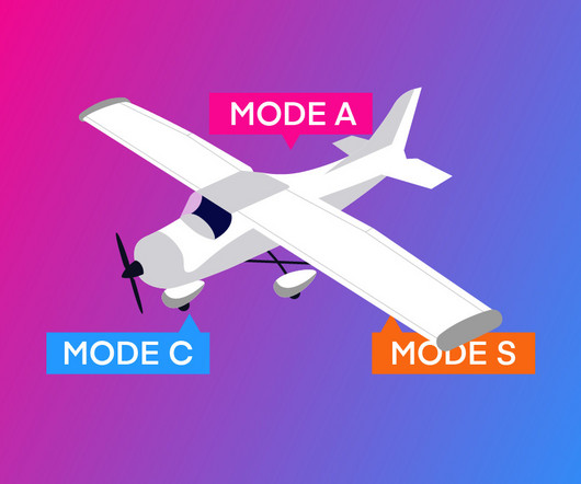
If the aircraft also has ADS-B In equipment, it can receive the following: Weather updates (FIS-B) Traffic information (TIS-B) Position reports from nearby aircraft This relationship between Mode S and ADS-B is important because in many areas where a Mode C transponder is required, ADS-B Out is also required.

article thumbnail

Class E Airspace Explained

Pilot Institute

Key Takeaways Class E airspace is the most common controlled airspace in the United States. It typically begins at 1200 feet AGL but can start lower in some locations. Use the Cessna 3-152 mnemonic to remember weather minimums for VFR. Let’s look at some of the functions of Class E.

Insiders

Sign Up for our Newsletter

This site is protected by reCAPTCHA and the Google Privacy Policy and Terms of Service apply.

Trending Sources

article thumbnail

Class B Airspace Explained

Pilot Institute

If the complexity of this busy airspace feels overwhelming, don’t worry. This article makes Class B airspace easy to understand. From entry and weather requirements to interacting with ATC, we have you covered. Key Takeaways Class B airspace surrounds the nation’s busiest airports. Airport, CA.

article thumbnail

Class C Airspace Explained

Pilot Institute

Note: VFR pilots can enter Class C airspace only if the weather meets certain minimum visibility and cloud clearance rules. To operate in Class C airspace, the FAA has set speed limitations to improve traffic flow and safety: Under 2500 feet AGL and within 4 NM of the main airport, the aircraft must maintain 200 knots or less.

article thumbnail

Common Mistakes Pilots Make at Non-Towered Airports

Pilot Institute

Pattern altitudes are typically 1,000 feet above ground level (AGL) for piston aircraft. Check the airports windsock or automated weather observation system (AWOS). SVFR is only available in controlled airspace (Class B, C, D, or E surface areas) where ATC services are available. This shouldnt be the sole factor, though.

Pilot 52
article thumbnail

Drone Mapping Made Easy: A Beginner’s Guide to Aerial Surveying

Pilot Institute

Understanding Airspace and Weather Conditions Before launching a drone mapping mission, check compliance with airspace regulations by using apps like Aloft – Air Control for no-fly zones and airspace classifications. Conduct mapping missions in favorable weather conditions to get the best data possible.

Payload 52